
Page 33 - John Barber's Oakham Castle and its archaeology
P. 33
2. Trench No.2 (Diagram E):
This was an east-west trench from a point on the
eastern edge of Trench No.1 above, roughly in line
with the middle of the three blocked up doorways in
the east wall of the hall: it was some forty-eight foot
long, and like Trench No.3, was dug in the 1957
season. It was laid out in such a manner as to
determine the eastward extent of the two rooms and
the passageway, which the excavations of the
previous year (ie Trench No.1) had revealed, and to
discover what, if anything, lay even further to the east.
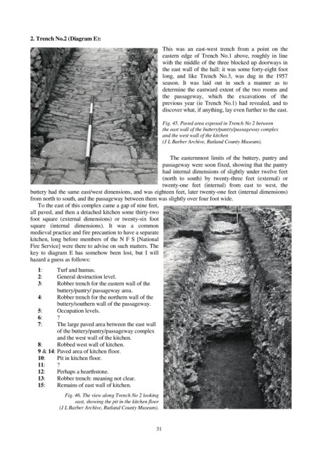
Fig. 45. Paved area exposed in Trench No 2 between
the east wall of the buttery/pantry/passageway complex
and the west wall of the kitchen
(J L Barber Archive, Rutland County Museum).
The easternmost limits of the buttery, pantry and
passageway were soon fixed, showing that the pantry
had internal dimensions of slightly under twelve feet
(north to south) by twenty-three feet (external) or
twenty-one feet (internal) from east to west, the
buttery had the same east/west dimensions, and was eighteen feet, later twenty-one feet (internal dimensions)
from north to south, and the passageway between them was slightly over four foot wide.
To the east of this complex came a gap of nine feet,
all paved, and then a detached kitchen some thirty-two
foot square (external dimensions) or twenty-six foot
square (internal dimensions). It was a common
medieval practice and fire precaution to have a separate
kitchen, long before members of the N F S [National
Fire Service] were there to advise on such matters. The
key to diagram E has somehow been lost, but I will
hazard a guess as follows:
1: Turf and humus.
2: General destruction level.
3: Robber trench for the eastern wall of the
buttery/pantry/ passageway area.
4: Robber trench for the northern wall of the
buttery/southern wall of the passageway.
5: Occupation levels.
6: ?
7: The large paved area between the east wall
of the buttery/pantry/passageway complex
and the west wall of the kitchen.
8: Robbed west wall of kitchen.
9 & 14: Paved area of kitchen floor.
10: Pit in kitchen floor.
11: ?
12: Perhaps a hearthstone.
13: Robber trench: meaning not clear.
15: Remains of east wall of kitchen.
Fig. 46. The view along Trench No 2 looking
east, showing the pit in the kitchen floor
(J L Barber Archive, Rutland County Museum).
31