
Page 18 - John Barber's Oakham Castle and its archaeology
P. 18
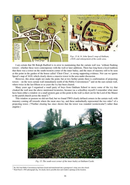
Figs. 13 & 14. John Speed’s map of Oakham,
                                                                 c1610, and enlargement of the castle area.


               I am certain that Mr Ralegh Radford is in error in maintaining that the curtain wall was ‘without flanking
            towers’, whether these were contemporary with the wall or later additions. There has long been a local tradition
            that there was a tower on the south-western corner of the inner bailey, and the mass of masonry still to be seen
            at this point in the garden of the house called ‘Choir Close’, is strong supporting evidence. Nor can we ignore
            Speed’s map of 1610, which clearly shows a massive tower in the area under discussion.
               However, this alone might not make the point, but at two further points there is confirmation of projecting
                                                                                  14
            towers – on the west curtain wall immediately north of the Public Conveniences  and on the east curtain wall,
            where twice in the last fifteen or so years the ivy has been cleared.
               Many  years  ago  I  organised  a  small  party  of  boys  from  Oakham  School  to  move  some  of  the  ivy  that
            cloaked the wall near the above mentioned lavatories, because (as a schoolboy myself) I remember what must
            have been either a window or a small postern gate at this point in the wall (a short cut for the Lord of the Manor
                                             15
            to the parish church across the moat?).
               This window or postern we did not find, but we found TWO clearly defined corners in the curtain wall, with
            masonry coming off towards where the moat once lay, and these undoubtedly represented the two sides* of a
            projecting tower. (*Further clearing has since shown that the tower was rounded (semicircular?) rather than
            angular.)


                                  Fig. 15. The south-west corner of the inner bailey at Oakham Castle.

            14  By 2012 the Public Conveniences had been closed and transformed into a greengrocer’s shop, now also closed.
            15
              Pearl Finch’s 1903 photograph (fig. 16) clearly shows possible door and window openings at this location.
                                                            16