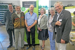
The Medieval Earthworks of Rutland
By Robert F Hartley
2nd edition (2023), A4, 133 pages, Paperback. ISBN 978-0-9548200-4-6
Leicestershire Fieldworkers. Monograph series, 5
Forty
years
after
the
publication
of
the
first
edition,
the
Leicestershire
Fieldworkers
held
the
launch
event
for
the
second
edition
of
Robert
F.
Hartley’s
seminal
work
on
The
Medieval
Earthworks
of
Rutland
at
Rutland
County
Museum
as
part
of
the
2023
Festival
of
Archaeology.
This
monograph
is
the
result
of
many
years
of
painstaking
survey
work
and
research.
The
author
has
revisited
sites,
redrawn
most
of
his
site
plans
and
elaborated
on
his
careful
interpretations
of
the
earthworks,
drawing
on
new
research
and,
occasionally,
including
new
earthworks
such
as
the
site
of
a
water
mill
and
pond
dam
in
Belton-in-Rutland
discovered
in
the
1990s.
Appropriately,
the
monograph
is
dedicated
to
Anthony
Squires
(1946–2021),
a
Loughborough
man
who
had
a
passion
for
natural
history
and
was
a
much
respected
landscape historian specialising in the ancient woodlands, deer parks and gardens of Leicestershire and Rutland.
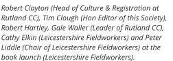
The
talks
at
the
book
launch
were
engaging
and
knowledgeable.
‘Fred’
Hartley
worked
with
Tim
Clough
and
Peter
Liddle
for
many
years:
Tim
Clough
was
the
Curator
of
Rutland
County
Museum
and
Oakham
Castle
and
Peter
Liddle
was
the
Archaeological
Survey
Officer
at
the
Leicestershire
Museums
Service
and
later
Leicestershire’s
Keeper
of
Archaeology.
The
three
have
been
friends
for
more
than
40
years
and
the
warmth
of
this
friendship
enriched
the
anecdotes
Messrs
Clough
and
Liddle
recalled
about
working
with
Hartley:
Hartley’s
talent
for
surveying
historical
landscapes,
the
enjoyment
and
satisfaction
he
got
from
it
and
how
Hartley
would
‘disappear’
for
days
doing
fieldwork.
Hartley
spoke
engagingly
about
how
he
adapted
the
‘crosshead
survey’
method
so
that
he
could
work
solo,
and
the
process
of
drawing
his
site
plans.
He
revisited
his
original
work
of
1983
motivated
by
three
rising
threats
posed
to
Rutland’s
earthworks:
construction
to
meet
the
demand for new housing; high intensity, mechanised arable farming practices; and the expansion of quarrying in the county.
The
second
edition
of
Hartley’s
The
Medieval
Earthworks
of
Rutland
is
the
fifth
monograph
published
by
the
Leicestershire
Fieldworkers.
In
the
same
format
as
the
original,
this
A4,
paperback
monograph
shares
the
same
clear,
crisp
and
highly
readable
typeset
as
the
third
and
fourth
in
the
Leicester
Fieldworkers’
series
of
monographs.
The
front
cover
has
a
stylised
reproduction
of
the
plan
of
the
manor
of
Lyndon
which
was
prepared,
probably
in
1662,
by
the
astrologer,
astronomer
and
professional
land
surveyor,
Vincent
Wing,
the
uncle
of
the
philosopher
and
astronomer,
Tycho
Wing.
With
109
pages,
the
second
edition
is
almost
twice
the
length
of
the
first.
The
A4
format
allows
for
generous
reproductions
of
plans,
maps
and
photographs.
In
total,
the
monograph
contains
twice
as
many
original
site
plans
(more
than
80),
17
landscape
maps
and
five
colour
illustrations.
Apart
from
the
author’s
site
plans,
treasures
among
its
illustrations
include
an
aerial
photograph
looking
east
over
Brooke
and
‘Town
Park’
from
1986,
the
central
part
of
the
1768
Ketton
estate
map,
a
colour
reproduction
of
Vincent
Wing’s
plan
of
the
manor
of
Lyndon
and
a
reproduction
of
the
1687
map
of
the
Clipsham
cum
Membris
Lordship made by Wing’s nephew, John Wing.
After
a
much-expanded
introduction
including
a
more
detailed
glossary
describing
the
characteristics
of
the
different
types
of
earthworks
found
in
Rutland,
Hartley
presents
his
gazetteer
and
site
surveys,
organised
by
the
1885
boundaries
of
the
civil
parishes
introduced
by
the
1866
Poor
Law
Amendment
Act.
In
Rutland,
these
boundaries
were
largely
in
agreement
with
those
of
the
medieval
parishes, except around Oakham, and have remained largely unchanged.
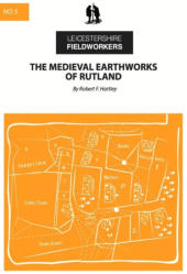
Hartley
’s
site
plans
are
full
of
fascinating
detail
for
the
reader
to
repeatedly
dip
into,
comprehensively
covering
Rutland’s
historic
landscape
and
features.
He
has
maintained
the
conventions
of
marking
parish
churches
in
solid
black
and
line
shading
other
buildings,
and
continues
the
tradition
of
making
accurate,
objective,
closely
observed
records
of
historical
landscapes
that
was
established
by
William
Stukeley
among
others.
Each
site
plan
is
accompanied
by
a
concise,
detailed
interpretation,
rich
in
references
to
other
works,
so
that
each
becomes
a
starting
point
for
those
who
wish
to
enrich
their
knowledge
of
the
site
and
its
context.
(The
new
edition
cites
45
works
in
contrast
to
the
13
books
referenced
in
the
first
edition.)
Although
I
moved
to
Rutland
more
than
ten
years
ago,
there
were
survey
sites
in
this
monograph
that
I
had
not
heard
of
before,
and
I
found
it
helpful
to
keep
to
hand
an
Ordnance
Survey
map
(there
are
map
references
for
each
site)
and
my
copy
of
An
Illustrated
Guide
to
the
Printed
Maps
of
Rutland
1576–1900
(Deadman
and
Brooks,
2012).
Although
readers’
enjoyment
does
not
depend
on
having
access
to
the
works
of
the
great
antiquarians
such
as
Thomas
Blore,
William
Stukeley
and
James
Wright,
reading
these
alongside
this
monograph
can
only enrich readers’ enjoyment, notably
Stukeley
’s Stanfordia Illustrata (1736–7).
In
conclusion,
I
would
recommend
the
second
edition
of
this
monograph
without
hesitation
to
anyone
who,
like
me,
is
fascinated
by
maps
or
interested
in
deepening
their
understanding
of
Rutland’s
landscape,
including
owners
of
the
first
edition.
It
will
also
be
an
essential
reference
for
landowners
on
whose
properties
these
earthworks
are
situated,
architects,
planning
officers
and
heritage
professionals
working
in
Rutland,
helping
them
to
understand
what
remains
of
individual
earthworks,
what
has
been
lost
and
their
wider
context.
Meantime,
the
monograph
has
wider
appeal
for
anyone
interested
in
Rutland’s
landscape
from
walkers
to
social
historians.
The
A4
format
will
appeal
to
walkers
interested
in
the
landscapes
they
are
walking
through,
and
the
monograph
will
fit
into
many
waterproof
map
cases.
Although
most
of
the
survey
sites
lie
on
private
property,
many
can
be
viewed
to
varying
degrees
from
Rutland’s
ancient
footpaths
and
bridleways
as
well
as
its
permissive
ways.
For
those
interested
in
the
social
history
of
Rutland,
Hartley’s
site
plans,
maps
and
interpretations
are
starting
points.
Study
of
this
guide
will
enable
the
inquiring
reader,
as
Tim
Clough
observes,
‘to
begin
to
populate
those
fields
and
their
strips
and
to
visualise
those
village
and
manor
sites’
(Hartley,
2023:
xiv),
further
brought
to
life
by
following
up
the
references
in
the
text
and
reading the works of the great antiquarians such as Thomas Blore, William Stukeley and James Wright.
Richard Hunt
References:
Deadman, D. and Brooks, C. (2012)
An Illustrated Guide to the Printed Maps of Rutland 1576–1900.
Leicester: The Landseer Press.
Hartley, R.F. (1983)
The Medieval Earthworks of Rutland.
1st edition. Leicester: Leicestershire Museums, Art Galleries and Records Service (Archaeological Reports Series, 7)
.
Hartley, R.F. (2023)
The Medieval Earthworks of Rutland.
2nd edition. Leicester: Leicestershire Fieldworkers (Monograph series, 5).

Researching Rutland
Copyright © Rutland Local History and Record Society. - All rights reserved
Registered Charity No 700273


Book Review


Researching Rutland
© Rutland Local History and Record Society
Registered Charity No 700273


Book Review
William Browne’s Town: The Stamford Hall Book 1465-1492
Stamford Survey Group in association with Stamford Town Council and
Stamford Civic Trust
Stamford is fortunate to have a Hall Book, a record of the council minutes
of the town. Until now it has remained in the town’s archives only to be
seen by historians with an appointment. With this transcript Alan Rogers
has made the first part of the Hall Book accessible to all and we are given
the opportunity to step back in time and discover what life was really like
in the fifteenth century. Future volumes are planned which will continue
the story of Stamford’s town affairs.
The book gives a remarkable insight into the lives of townspeople in
medieval England covering the years from 1465, shortly after the town’s
incorporation, until 1489 just after the death of William Browne. William
Browne was a very rich and important Merchant of the Staple. He
controlled the affairs of the town during this period, serving as Alderman
on several occasions. His legacy to Stamford is All Saints’ Church and
Browne’s Hospital.
As today, rules and regulations governed the lives of townsfolk. The
minutes record laws forbidding Sunday trading and fines for leaving
horses tied up in the wrong places on market days – as the editor
comments, ‘There were parking penalties even in medieval Stamford’. We
also find that there were designated places for dunghills and times when
animals could be brought into town. From this book we learn how law
and order was enforced and the punishments meted out to wrongdoers.
Perhaps the most interesting aspect of the volume is the tremendous
number of different trades pursued in the town. The wardens strictly
controlled the craftsmen to ensure the quality of goods and there was a
diversity of rules governing the guilds and the pageant of Corpus Christi.
Alan Rogers has had close links with Stamford and readers will no doubt
be familiar with his books The Medieval Buildings of Stamford
(Nottingham 1970), The Book of Stamford (Buckingham 1983) and, with
JS Hartley, The Religious Foundations of Medieval Stamford
(Nottingham 1974). He has also been closely involved with local history in
Rutland, most recently in Uppingham, inspiring and encouraging local
historians to record aspects of the history of that town.
For this volume Professor Rogers has written an excellent introduction
including the insight he has gained about the role of William Browne in
making the transcript. He also adds useful comments throughout the
volume and there is an excellent index. It is a shame that the Editorial
Conventions are not at the front of the book and a glossary would have
been useful for those less familiar with the legal terms of the medieval
period. Do not however be deterred by the plain cover: inside it is a
fascinating record not just for people in Stamford but for anyone
interested in town life in the Middle Ages. It is a book to dip into, and read
aloud it comes to life. It certainly merits a place on the bookshelf of
anyone interested in history.
Jean Orpin